
Dwaars door Vlaanderen is today, its name is literally “Across Flanders” only it covers a tiny portion of Flanders. Similarly this Sunday’s Ronde van Vlaanderen doesn’t tour much of Flanders, instead it loops around a very small part of the region. As do many of the other spring classics.
The map above shows Belgium within the thick green national border and the Flanders-Wallonia border running east-west, as well as the circle of Brussels.
The red lines are the routes of all the events organised by Flanders Classics (Omloop Nieuwsblad, Ronde van Brugge, In Flanders Fields/Wevelgem, Dwars door Vlaanderen, Ronde van Vlaanderen, Scheldeprijs, Ronde van Limburg, Brabantse Pijl).
The other races are the independently run Kuurne-Brussels-Kuurne in dark purple, the Nokere Koerse is light purple while pink is the E3 Saxo Classic route, light blue for the Koksijde Classic and dark blue for the GP Monsére.
You might prefer to see each race in a different colour. But the point here is not to differentiate each course more to show how many overlap. It’s less a map and more a bowl of spaghetti. Trying different colours actually doesn’t work well because so many overlap.
As you can see a lot of Flanders isn’t visited by the major bike races, plenty of Flemish residents don’t exactly have a spring classic on their doorstep. The Scheldeprijs might be around Antwerp to the north but has plenty of the course in the Netherlands.
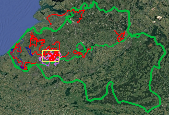
Look at the map again and this time there’s an added yellow rectangle. This measures 30km by 20km. Inside it sit most of the Omloop, Kuurne, Nokere, E3, Dwaars and Ronde routes. It’s here that sit many of the famous climbs, think of the Paterberg, Oude Kwaremont, Taaienberg and Molenberg.

The screenshot from Dwars door Vlaanderen today includes a white line, that’s the Nokere Koerse finish painted on the road from a few weeks ago. It’s why the guy with the “LUC” sign can appear so many times along the course of a race.
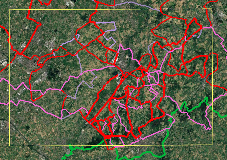
The image above zooms in on the same 30km by 20km zone. A lot of races within this area overlap. There can be cobbled sectors taken one direction that are reversed in another race but often there’s only one right way. Nobody wants to race down the Paterberg.
By themselves most of these climbs are modest, the Taaienberg can often be crucial but it is about 600m long and lasts just over a minute in these races. It’s the accumulation and distance that’s needed.
Geography means some races have few features to break up the peloton unless the wind is blowing. A sprint finish can be thrilling but the ride to get their can feel processional for TV viewers. Since the last decade many race organisers, including plenty outside of Flanders, have sought to add more obstacles and jeopardy in order to make the TV experience more lively.
So in Flanders organisers head for the hills and concoct a course designed to tackle as many climbs and cobbles as possible and most of these are in a relatively small area, sometimes branded the heuvelzone, the “hill zone”. The twisting and turning to achieve this compounds matters as races zig and zag through corners and junctions.
It used to be thought that learning the lie of the land was an advantage in racing, knowing where a road widened and allowed you to overtake before a key climb or cobbled sector could save energy. Now a lot of this lore has been mapped.
There’s now familiarity for riders and spectators alike. The current Omloop Nieuwsblad finale has the same route as the old Ronde. Meanwhile the current Ronde has the same Oude Kwaremont-Paterberg-finish in Oudenaarde since 2014 now and feels very much like a known quantity
Conclusion
Many of the Flemish classics take place in a small area and the same roads get criss-crossed? It’s no secret and obvious to many. But this post just puts all the Flemish classics onto the same map to visualise this.
The post Touring Flanders? first appeared on The Inner Ring.