
It’s not easy doing recon rides at the moment in Europe. It’s -11°C in Gavarnie and -10°C in Cari right now so those days of the Tour and Giro can wait until spring or even better, summer. But Stage 11 of the Giro was completed last weekend.
The route takes an predictable course along the coast before turning inland for a late climb to spice things up. Finding the exact route for this took a moment and if the climb is tricky, more so the descent.
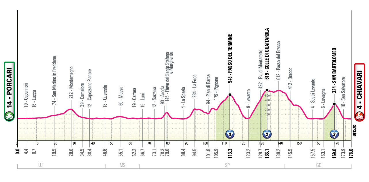
Glance at the profile and you can see the finale where the route goes through Sestri and to Lavagna and then takes the climb to San Bartolomeo before descending to San Salvatore and then a flat run to the finish in Chiavari. So which roads to ride?

Here’s a screengrab map from Google above and you can see San Bartolomeo to the north of Chiavari up on the top left. It should be somewhere up there and back down, right? Only go back to the altitude profile and the road is supposed to reach 334m above sea level and the roads around San Bartolomeo there only reach 220m. So it’s probably not that way.

Let’s turn to the Giro’s own map as seen above. It shows the race route heads for the hills to the north-east of Chiavari instead, although it still says San Bartolomeo too. Trace the Giro’s loop and the race goes via the SP34 up to Cogorno, not San Bartolomeo. The mystery, if we can call it that, is solved because on the road up to Cogorno there is another, different small place called San Bartolomeo. You won’t know it by riding through as there are no signs but this smaller San Bartolomeo is marked the IGMI maps of Italy, the national cartographer. Keep going up to Cogorno and the top of the climb sits at 330m. That’s a match.
Conspiracy? Probably not. The myth goes that the Giro was infamous for surprise climbs, a bump on the profile that turned out to be a wall, a modest categorised climb on the map marked a brute of a mountain pass. Only examples are hard to find. But it was still possible to catch-out the peloton by venturing onto new roads that only a handful of locals knew and where maps and the terrain were less familiar. Today that’s impossible as cartography software means every metre of the course is known to teams; they’ve already got the GPS tracks of the Giro as it happens.
Moral of the story
A tale of competing maps and race organisers who are not locals and so grab labels as they pass by or trace the route on a map. The less local the race, the more it happens. Hopefully no spectators wait in vain at the other San Bartolomeo.
It’s very notable in the Tour de France where the “Côte de [Placename]” formula is rarely used by locals and can sometimes mask the real name of a small mountain pass.
Recon notes
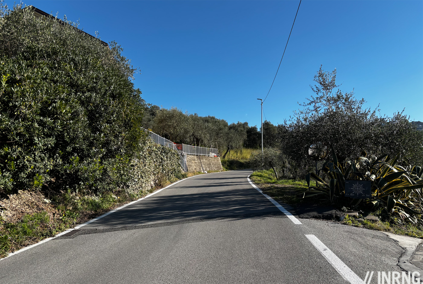
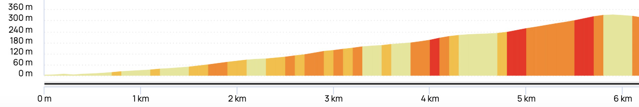
So what’s the finish like? The final climb is 5.8km at close to 6%, nothing much on paper but on tarmac this was worth the visit. The previous climbs of the day are more traditional mountain passes that help traffic cross from one place to the other, they’re more even and gradual. This one is just a series of roads linking villages in the hills that twists up past olive groves.
Coming in the second week of the race this ought to be a breakaway day and this final climb should be decisive. It’s steep for a moment out of Lavagna in a way the profiles don’t pick up and an early move here could work as the bendy road all the way up means a rider be out of sight even if they have 15 seconds.
The hardest part comes at the top with sustained double-digit percentages for the final kilometre, anyone who has managed the climb well and has some punch left can make a move as there’s less than 10km to go and little time left to chase.
There’s a short balcony section over the top and then comes the descent. This could be the real story on the day. The route down even goes via a place called Breccanecca which sounds funny in the moment, a brecca ya necca descent right?
Only riding down wasn’t a laugh as it’s steep with tight, blind bends and off-camber corners. It briefly triggered thoughts of an email the organisers or the CPA because it was beyond “technical” in places. It is still a normal road used daily by locals, it’s just going to be awkward to rush down under pressure but the surface at least is alright which helps. Hopefully it’s a breakaway day, the sun is out and the final climb is selective so we won’t see a group barrel down to Chiavari with riders jostling for position. There’s only a few kilometres of flat to reach the finish on the sea front and deducing from the map, no late surprises.
It’s too early for a preview but one small piece of news today is that Michael Valgren (EF) is down to ride the Giro and if he can returning to winning ways he’s the archetypal rider for a day like this, if not then Jan Christen (UAE), Lorenzo Fortunato (XDS-Astana) and Thibau Nys (Lidl-Trek) come to mind.